
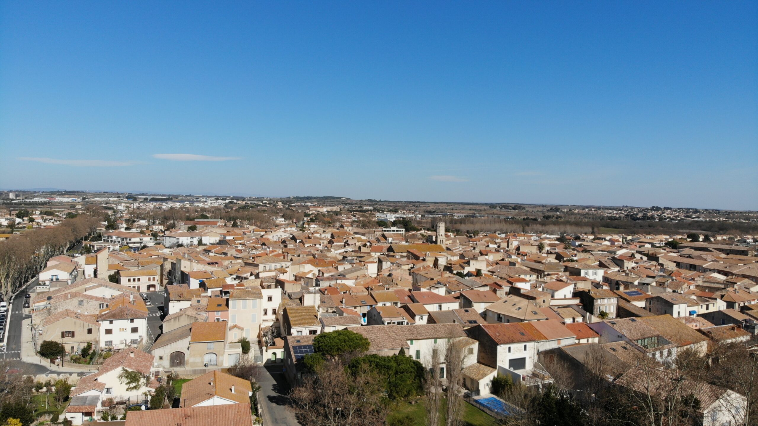
The town planning department can provide you with information and support for your property projects.
Town Planning Department - Hôtel de Ville, 1 rue de la Marianne, 34420 Villeneuve-lès-Béziers
Tel: 04 67 39 47 80 - Email: urbanisme@villeneuve-les-beziers.fr
Related pages
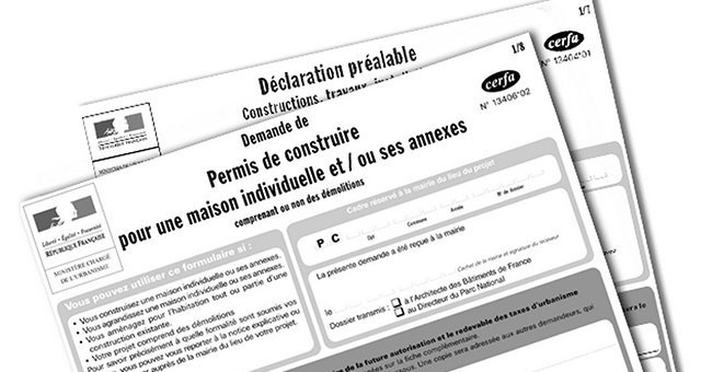
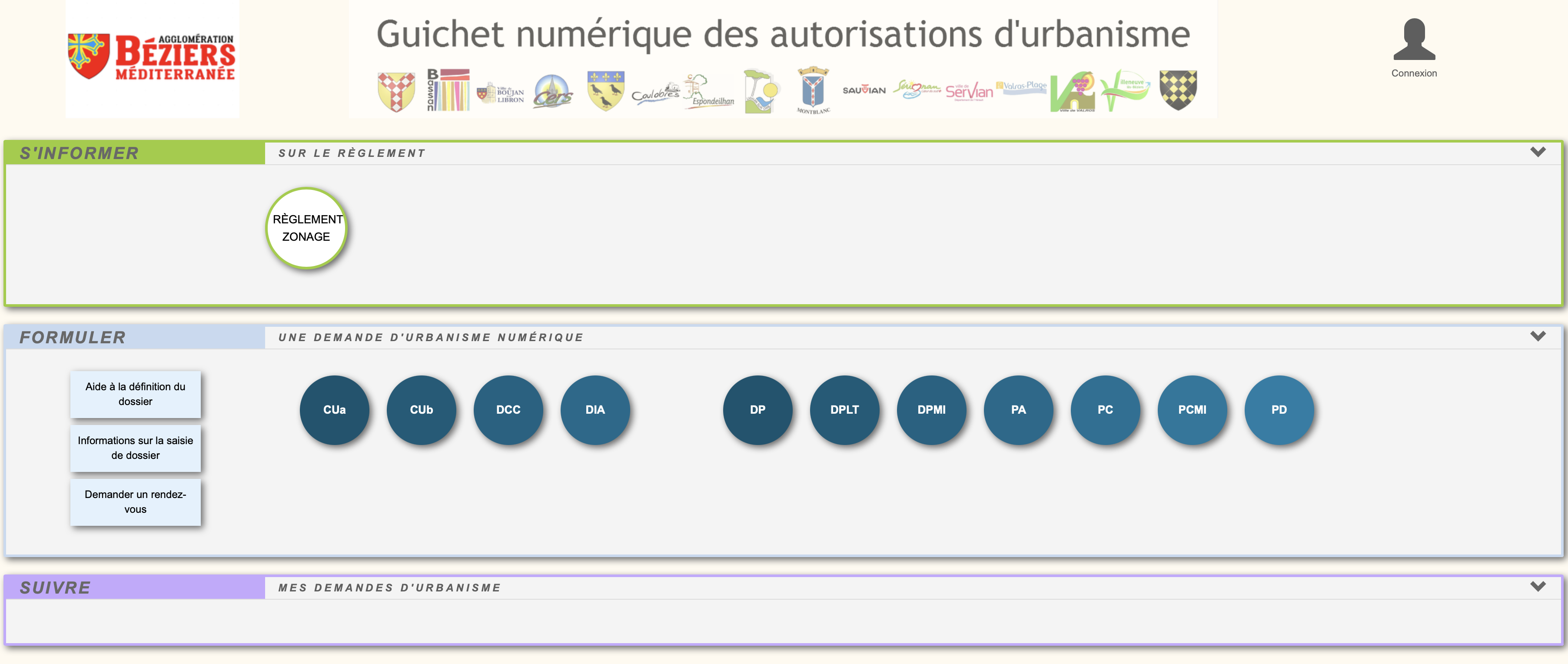

Electronic applications for planning permission

Since 1 January 2022, we have been ready to receive your applications quickly and easily. You will need to identify the official Cerfa that you will need to select in the submission portal. You can access the Cerfa from the public service.
IMPORTANT: If you make a mistake in filling in the form, forget to submit a document or submit the wrong document (etc...), the application cannot be amended without the intervention of the instructing officer. Please do not submit a new application and send an e-mail to the Planning Department mentioning the errors.
Also, in the event of an unintentional error (e.g. submitting a file twice), you can request that your file be withdrawn. See procedure here: https://gnau.beziers-mediterranee.fr/gnau/fichiers/05_DEMANDER_SUPPRESSION_DOSSIER.pdf
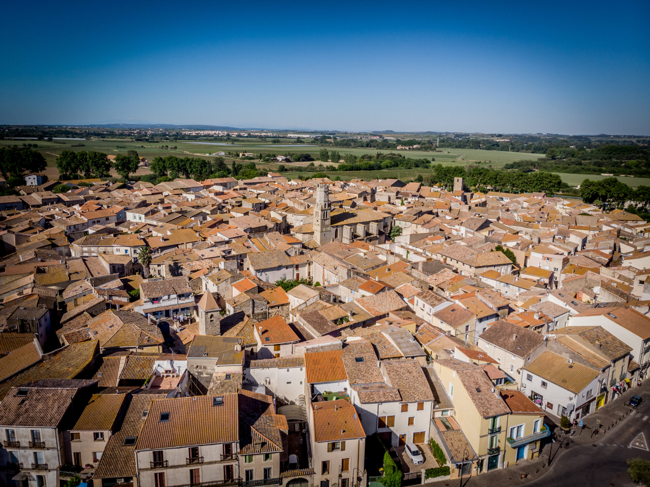
Local Town Planning Scheme (PLU)

In this section, you can consult the commune's Local Planning Scheme and its regulations by visiting the official Géoportail de l'urbanisme website.
Formalities

Planning permission allows the local authority to check that the work complies with planning regulations. Depending on the type of project and the location, you will need to submit an application for planning permission (building permit, development permit, etc.) or a preliminary works declaration. Before starting any work, it is advisable to apply for a planning certificate to obtain information about the plot of land on which the work is to be carried out.
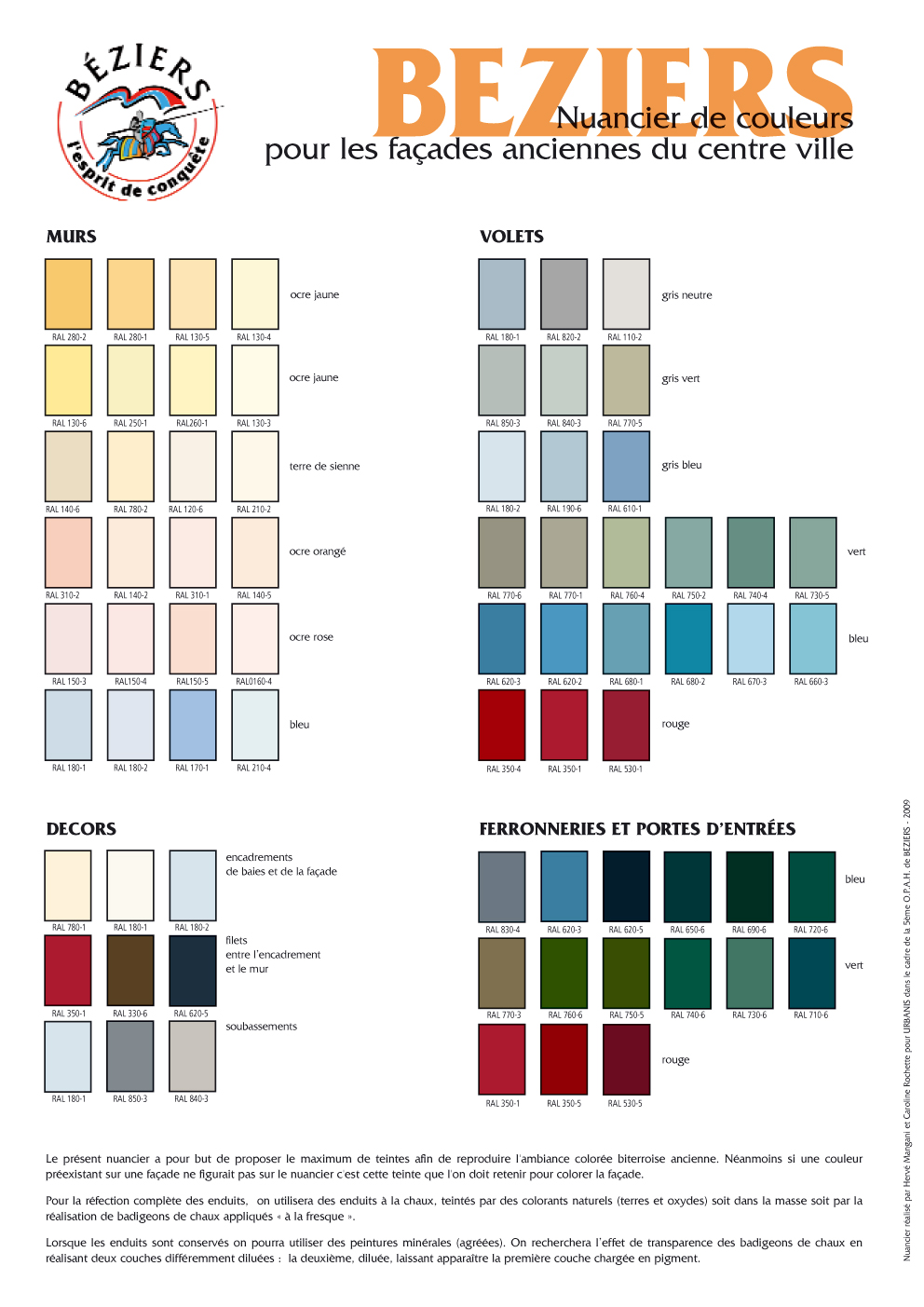
Facade renovation
The restoration of buildings is subject to prior declaration in all sectors and to the agreement of the Bâtiments de France architect in the town centre.)
The file consists of :
- Preliminary Declaration Form
- DP 1 : Location map
- DP 11: Project description : example
- DP 5: Representation of the project (elements may be indicated by hand on the photographs)
- DP 6 : Representation of the project after modification (photomontage, sketch...)
- DP 7: Photographs of the façade
- DP 8: Photographs of the façade and neighbouring façades from the property or from the street
Installing an air conditioner
Changes to the external appearance of a building are subject to prior declaration in all sectors and to the agreement of the architect of Bâtiments de France in the town centre.
The file consists of :
- Preliminary Declaration Form
- DP1 : Location map: planCadastralNormalisecentrevilleAA
- DP 11: Description of the work: description of the system (materials, colour, dimensions) and location of the system (roof, attic, box, etc.).
- DP 5: A representation of the project, e.g. a diagram, a sketch, possibly photographs of the roof and facade with an indication of where the device will be installed.
- DP 6: a graphic document showing the project after modification (photomontage, sketch, etc.)
- DP 7: Photographs of the façade and/or roof
- DP 8: Photographs of the façade and neighbouring façades and/or the roof from the property or from the street
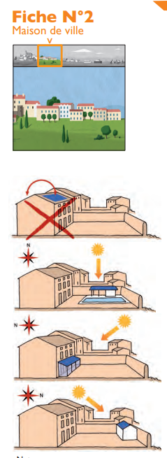
Installing solar/photovoltaic panels
Changes to the external appearance of a building are subject to prior declaration in all sectors and to the agreement of the architect of Bâtiments de France in the town centre (500m perimeter around the church).
When the building is located within the protection perimeter of a listed historic monument (church), the Architecte des Bâtiments de France may not authorise the installation of photovoltaic panels on the roof of the building, particularly if their surface area is too large in relation to the surface area of the roof.
Where possible, panels may be installed on the roof of a single-storey annex, not visible from the public space, and not on the main roof of the building.
They could also be studied on a pergola covering a terrace if necessary.
Otherwise, the project may be accepted if it complies with the following:
- Installed on top of the roof, preferably in a single strip (using a simple rectangular geometry) just above the eaves on the lowest part of the slope. Under no circumstances should they be close to the ridge. The longest side of each panel should be laid in the direction of the slope of the roof.
- The panels will be brown or terracotta in colour.
- The finish will be matt. Frames and supports will be the same colour as the panels.
The file consists of :
- Preliminary Declaration Form
- DP 1 : Location map
- P 11: Description of the work: description of the device (power, materials, colour, dimensions) and location of the device.
- DP 5: A representation of the project, e.g. a diagram, a sketch, possibly photographs of the roof and facade with an indication of where the panels will be installed.
- DP 6: a graphic document showing the project after modification (photomontage, sketch, etc.)
- DP 7: Photographs of the roof
- DP 8: Photographs of the roof from the site or from the street
Sources: The Unités Départementales de l'Architecture et du Patrimoine (UDAP), the CAPEB, the C.A.U.E and the Agence Locale de l'Energie have joined forces to produce this guide.
Extracts
Land registry
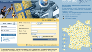
This service allows you to search, view and order these map sheets.
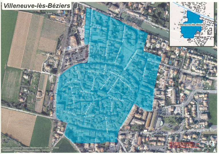
Rental permits
The Communauté d'Agglomération Béziers Méditerranée has introduced a "permit to rent" scheme to combat substandard housing. The municipality of Villeneuve has adopted this scheme for a given area (see map).
This prior authorisation is issued by the Communauté d'Agglomération to owners who wish to launch a new letting of their property.
If your property falls within the area covered by the scheme and you change tenants, you must apply for prior authorisation to let it.
You can contact the Agence de l'Habitat if you have any questions about the scheme. A technician will carry out an inspection of the property. Authorisation to let the property may be granted, subject to conditions or refused. Reasons will be given for any decision to refuse or grant permission, and will specify the nature of the work or improvements required.
Contact details
Agence de l'Habitat, 1 Avenue du Président Wilson, 34500 BEZIERS
Tel.: 04.99.41.34.94
Mail : agencehabitat@beziers-mediterranee.fr
Cerfa form : cerfa n°15652*01
Grants and subsidies - Housing
To find out all you need to know about the support available for housing and energy saving in the area, the Agglo provides a one-stop shop: the Agence de l'Habitat (Housing Agency), run by a team of technicians.
It offers information and free, personalised advice. It will help you with the procedures and aid available for your project (ANAH aid and the Agglo's own funds).
Contact:
Agence de l'Habitat 1 avenue du Président Wilson
34500 Béziers
8.30am-12.30pm and 1.30pm-5pm
Tel.: 04 99 41 34 94
agencehabitat@beziers-mediterranee.fr
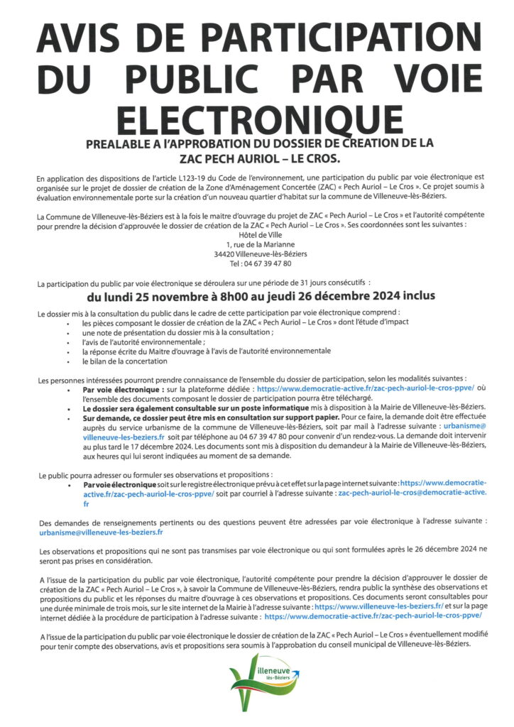
Notice of electronic public participation
05/11/2024
NOTICE OF ELECTRONIC PUBLIC PARTICIPATION PRIOR TO APPROVAL OF THE DOSSIER FOR THE CREATION OF THE "LA CLAUDERY" ZAC.
In accordance with the provisions of article L123-19 of the French Environment Code, an electronic public consultation is being organised on the project to create the "La Claudery" Concerted Development Zone (ZAC). This project, which is subject to an environmental assessment, concerns the extension of the "La Claudery" business park in the municipality of Villeneuve-lès-Béziers.
Public participation by electronic means will take place over a period of 31 consecutive days: from Monday 25 November at 8:00 a.m. to Thursday 26 December 2024 inclusive.
Dedicated platform :
https://www.democratie-active.fr/zac-claudery-ppve/ where all the documents making up the application file can be downloaded.
Electronic register :
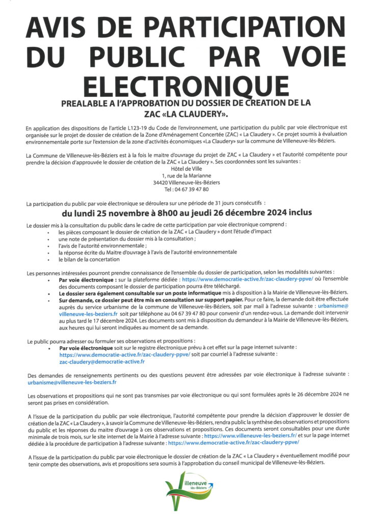
At the end of the electronic public participation, the authority responsible for taking the decision to approve the "La Claudery" ZAC development file, i.e. the Commune of Villeneuve-lès-Béziers, will publish a summary of the public's comments and proposals and the project owner's responses to these comments and proposals. These documents will be available for consultation for at least three months on the Town Hall's website and on the website dedicated to the participation procedure at the following address: https://www.democratie-active.fr/zac-claudery-ppve/
At the end of the electronic public participation period, the "La Claudery" ZAC development plan, which may be amended to take account of comments, opinions and proposals, will be submitted to the Villeneuve-lès-Béziers town council for approval.
05/11/2024
NOTICE OF ELECTRONIC PUBLIC PARTICIPATION PRIOR TO APPROVAL OF THE CREATION DOSSIER FOR THE "PECH AURIOL - LE CROS" ZAC.
Pursuant to the provisions of article L.123-19 of the Environmental Code, an electronic public consultation is being opened and organised from 25 November to 26 December 2024 inclusive concerning the project for the "Pech Auriol - Le Cros" ZAC development plan.
Public participation by electronic means will take place over a period of 31 consecutive days: from Monday 25 November at 8:00 a.m. to Thursday 26 December 2024 inclusive.
Dedicated platform :
https://www.democratie-active.fr/zac-pech-auriol-le-cros-ppve
Electronic register :
https://www.democratie-active.fr/zac-pech-auriol-le-cros-ppve
At the end of the electronic public participation, the authority responsible for taking the decision to approve the "Pech Auriol - Le Cros" ZAC development dossier, i.e. the Commune of Villeneuve-lès-Béziers, will publish a summary of the public's comments and proposals and the project owner's responses to these comments and proposals. These documents will be available for consultation for a minimum of three months on the Town Hall's website and on the website dedicated to the participation procedure at the following address: https://www.democratie-active.fr/zac-pech-auriol-le-cros-ppve/
At the end of the electronic public participation period, the "Pech Auriol - Le Cros" ZAC development plan, which may be amended to take account of comments, opinions and proposals, will be submitted to the Villeneuve-lès-Béziers town council for approval.
La Claudery ZAC project
By resolution no. 2021/02 of 22 February 2021, the Town Council decided to open up the "La Claudery" sector to urban development under the "La Claudery" ZAC procedure.
The purpose of this sector is to redevelop an economic area that lacks coherence and overall development, and to create a service centre.
- ZAC La Claudery project consultation file
- Principle of creating a ZAC (joint development zone) in the Claudery sector: deliberation no. 2021/02 of 22/02/2021
- Rectification of the sector's vocation: deliberation no. 2022/04 of 07/02/2022
- VLB Claudery study (CBE initial status Feb 2022)
- Study of the natural component of the impact assessment (VNEI) CBE oct. 2022
Update 2024:
La Montagnette" development project
ZAC La Montagnette consultation file
Study VLB ZAC La Montagnette initial state project La Montagnette CBE
Meeting on 21/04/2022 for presentation and discussion with the owners.
***
Cancellation of the ZAC la montagnette procedure - launch of a comprehensive development project La Montagnette
ZAC Pech Auriol project
Pech Auriol ZAC project consultation file
VLB study ZAC Pech Auriol (Initial status Feb 2022)
Study of the natural component of the impact assessment (VNEI) CBE oct. 2022
Update 2024:
923 ZAC Pech Auriol - Le Cros VLBZ - Creation - EFD EnR - V2 - 240307
923 ZAC Pech Auriol - Le Cros VLBZ - GHG balance study - V2 - 240307
Compensatory project for the Castelfort Montblanc estate
INITIAL ECOLOGICAL STATUS_COMPENSATORY SITE CASTELFORT_ALTEMIS-202312
New Montpellier-Perpignan line
You can find all the information about the project on the official websites:
Zoning plan of the PLU with reserved sites n°11 and 12 for SNCF RÉSEAU :
PPR
Flooding PPR
Approval date: 08/11/2007
Zoning maps
Appendices
MINGUEZ" technological risk prevention plan
Approval date: 06/03/2013
Appendices
GAZECHIM" technological risk prevention plan
Approval date: 03/08/2015
Appendices
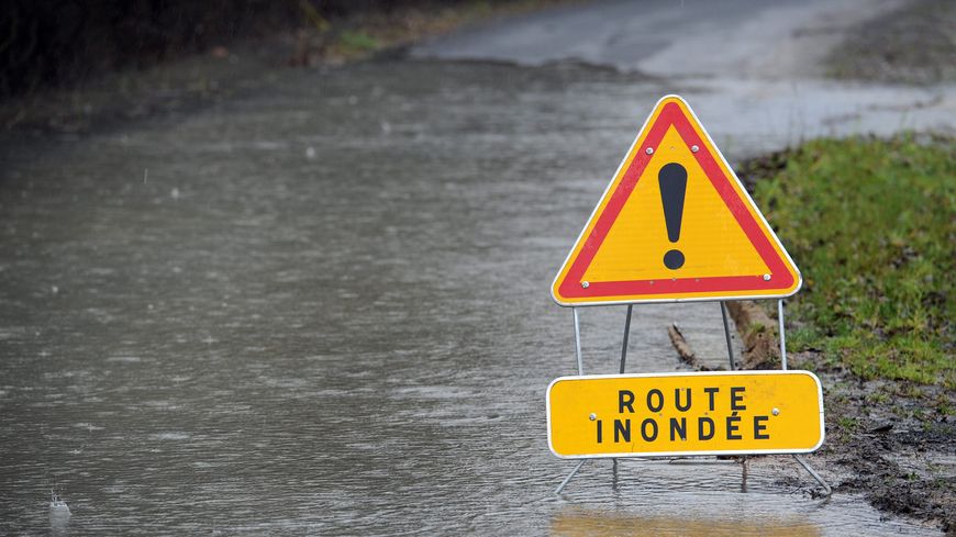
Statement of information following the floods of October 2019
RISK STUDIES NOTIFIED TO LOCAL AUTHORITIES
When a natural risk prevention plan is approved for a municipality, this plan provides a precise framework for building possibilities. However, it is not the only source of information to be taken into account, and all available additional knowledge of the risks must be used to assess the risk, particularly when drawing up town planning documents and examining planning permission. The Prefect must provide the municipalities with all the technical studies at his disposal that are necessary for them to exercise their town planning powers (Article L.132-2 of the Town Planning Code). To this end, the studies listed below have been brought to their attention. Source : Prefecture of Hérault
Flooding
28/09/2020
Hazard map for the flood of 23 October 2019 and associated planning notice
Appendix - PAC- Alea flood map Villeneuve-les-Beziers 2020-09-28
Appendix - PAC - leaflet associated with flood hazard map 23 October 2019
PAC_PHE_Villeneuve_les_Beziers_2020_09_28
Multi-risk
09/06/2017
Natural or technological risk definition sheet(s) for campsites and residential leisure parks in the Hérault. These sheets summarise, for each establishment and based on all the information drawn up by or at the request of the State, the delimitation of areas subject to foreseeable natural or technological risk and the extent of exposure. A map showing the location of the campsite in relation to the risks taken into account is also appended.
Rainwater drainage regulations for the Communauté d'Agglomération Béziers Méditerranée
The purpose of these regulations is to define the specific measures prescribed for the territory of the agglomeration community in terms of run-off control, treatment and discharge of rainwater into public underground or open-air networks. To this end, it specifies the general legislative framework.
Unroll the extract from the rules
7- General rules
a) It is forbidden to connect rainwater to the sewerage system or to an independent sewerage system.
b) Any increase in runoff caused by new waterproofing (creation or extension of existing buildings or infrastructures) must be compensated for by the installation of rainwater storage systems on the plot (infiltration or retention basins) or other alternative techniques*.
New waterproofing must be compensated for to the extent of 130 litres/m². (minimum) with a maximum leakage rate of 50 l/s per hectare of waterproofing.
If infiltration is not possible (or if the infiltration rate is insufficient) and there is no outlet, diffuse spreading may be considered at a regulated rate of 5 l/s/waterproofed hectare, subject to acceptance by the municipality.
The retention volume to be used in this case is : 170 l/m² of waterproofing.
c) The volume stored must be emptied by infiltration as a priority and not connected to the public network.
d) For building permits involving the demolition of existing buildings, the sizing of the works must take into account all the waterproofed surfaces of the land unit, regardless of the previous degree of waterproofing.
e) In the case of grouped urban development projects (housing estates, ZACs, etc.), storage facilities must be shared by the whole project in order to avoid storage on each plot. Storage facilities created as part of a subdivision permit must be sized for the roadway and for the total waterproofed surfaces likely to be created on each lot.
* Alternative techniques complement or replace conventional sewerage systems. Their main function is to limit peak flows downstream in order to prevent the concentration of water in saturated networks:
- by infiltration when the soil is suitable and outside the catchment protection area,
- by temporary storage of rainwater before releasing it at a controlled rate into the downstream network (drains, gutters, ditches, etc.) if infiltration is impossible or prohibited,
- by combining temporary storage and infiltration.
A non-exhaustive catalogue of plot-based storage techniques is presented in the appendix to the regulations: ditches, drainage trenches, storage roofs, porous soils, reservoir pavements, etc.

Information packs Town Hall
Dossier d'Information Mairie Free
Avenue Pierre Bérégovoy Pôle Méditerranée
Dossier d'Information Mairie
(Complies with the specifications of the Bee Law and the Order of 12 October 2016)Concerning the installation of a new radio installation on site T04D49
3 avenue ANDRE PALMADE 34420 VILLENEUVE-LES-BEZIERS
Dossier information Mairie - ANDRÉ PALMADE T04D49
Dossier d'Information Mairie
(Complies with the specifications of the Bee Law and the Order of 12 October 2016)Concerning the installation of a new radio installation site T03FA1 to replace another - Chemin du Cros 34420 CERS
Link to dossier : Information folder Mairie Ch du Cros
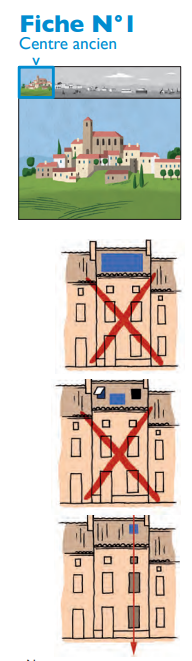
Advice sheets: maintaining, renovating or building in old town centres
To preserve the heritage and harmony of old town centres, the Drac Occitanie has joined forces with all 13 of the region's Unités Départementales de l'Architecture et du Patrimoine (Udap) and Conseils d'Architecture, d'Urbanisme et de l'Environnement (CAUE) to produce "Old Town Centres" advice sheets.
These fact sheets are an advisory and educational tool aimed primarily at the general public and all those involved in the living environment. They serve as a guide for work in old town centres to maintain, rehabilitate, renovate or build.
Each advice sheet focuses on a specific aspect of architecture and landscape: facades, roofs, windows, shutters, doors, ironwork and thermal comfort.